
South Shore: Community Guide to the Lake Chelan Valley
Lakeshore Corridor, State Parks, Fields Point Landing, and the Road to Twenty-Five Mile Creek
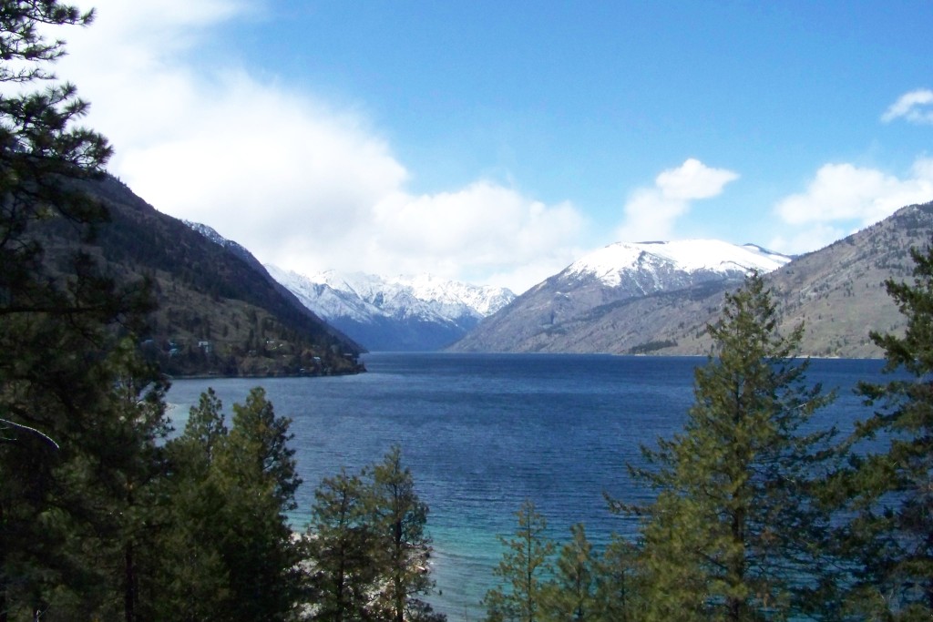
The South Shore of Lake Chelan is the unincorporated shoreline and foothill corridor extending west from the City of Chelan along the lake’s southern edge. Locals generally describe the South Shore as the stretch beginning where State Route 971 (South Lakeshore Road) branches off U.S. Highway 97A at Pat & Mike’s and continuing approximately 17 miles along the water to Twenty-Five Mile Creek State Park, where the paved lakeshore road ends and mountain roads climb toward Stormy Mountain and Shady Pass.
Rather than centering on a single downtown grid, the South Shore is a linear lakeside community of year-round residences, summer cabins, hillside vineyards, state park campgrounds, and established waterfront enclaves including The Cove and the historic Lake Chelan Yacht Club at Hollywood Beach. Farther up-lake, it is home to Fields Point Landing — where travelers can park and catch the Lady of the Lake passenger boat to the upper lake — making the South Shore both a residential neighborhood of the lower valley and the final road-accessible corridor before Lake Chelan enters its roadless upper basin.
Location, Roads, and Corridor Geography
The eastern gateway to the South Shore sits approximately three miles southwest of downtown Chelan along U.S. Highway 97A, where State Route 971 begins at Pat & Mike’s (53 S. Lakeshore Road). From that junction, SR 971 follows South Lakeshore Road west along the southern shoreline of the lower lake’s Wapato Basin for roughly six miles to Lake Chelan State Park (7544 S. Lakeshore Road). At the state park junction, SR 971 turns inland and climbs south through Navarre Coulee for nine miles to rejoin U.S. Highway 97A near Winesap.
Beyond Lake Chelan State Park, South Lakeshore Road continues northwest as a Chelan County road following the contours of the shoreline. Roughly three miles past the state park sits the sheltered bay and waterfront community known as The Cove (11155–11415 S. Lakeshore Road), followed a mile farther northwest by the Lake Chelan Yacht Club on Hollywood Beach (12220 S. Lakeshore Road). Along this middle reach, the lake constricts at the Narrows — a quarter-mile-wide glacial threshold separating the shallower Wapato Basin from the much deeper Lucerne Basin up-lake — while the bright orange mineral-stained rock face of Slide Ridge rises sharply above the road. About seven and a half miles northwest of Lake Chelan State Park (about 14 miles from the U.S. Highway 97A junction at Pat & Mike’s), the road reaches Fields Point Landing (17100 S. Lakeshore Road), where drivers can park and board the Lady of the Lake, before continuing another three and a half miles to terminate at Twenty-Five Mile Creek State Park (20530 S. Lakeshore Road, about 18 to 20 miles total from downtown Chelan).
History and the 1945 School Bus Memorial
Early travel and homesteading along the South Shore were shaped by steep terrain and the glacial breaks cutting through the Chelan Mountains. Navarre Coulee takes its name from Ignatius A. Navarre, a pioneer surveyor and one of the earliest non-Native settlers on Lake Chelan, who may have visited the area as early as 1884 and filed a homestead claim on the lake’s south shore in 1886. In 1901, the steep Navarre Coulee wagon grade was cut from 25 percent to about 6 percent, improving an early route between the Columbia River valley and the south shore of Lake Chelan, although the main early access to the lake was by the wagon roads through the Chelan River gorge. Farther up-lake at Twenty-Five Mile Creek, the U.S. Forest Service established a ranger guard station in 1907 — later rebuilt by the Civilian Conservation Corps around 1940 — to manage public lands across the Chelan drainage.
Approximately one mile east of Lake Chelan State Park along SR 971 (South Lakeshore Road) stands the Lake Chelan School Bus Tragedy Memorial, known locally as the Bus Monument. On the morning of November 26, 1945 — the Monday after Thanksgiving — a Lake Chelan School District bus driven by recently returned World War II veteran Royal J. “Jack” Randle was traveling toward Chelan in a heavy snowstorm with 20 South Shore students and one adult passenger aboard. After striking a rock outcropping along the narrow shoreline road, the bus slid down a 30-foot embankment and plunged into the deep waters of Lake Chelan. Five students and the adult passenger escaped through broken windows, while 15 students and driver Jack Randle drowned in the deadliest school bus accident in Washington State history.
Following the tragedy, Chelan students and local businesses raised money to build a roadside stone monument and small memorial park overlooking the lake near the site, and the victims’ families have maintained it since. Inscribed with the names and ages of the 16 victims, the Bus Monument remains one of the valley’s most solemn and enduring historical landmarks.
State Parks, Fields Point Landing, and Shoreline Access
Public shoreline access along the South Shore is anchored by two Washington State Parks and the U.S. Forest Service ferry terminal at Fields Point Landing, making the corridor a central hub for camping, boating, and upper-lake travel.
Lake Chelan State Park
Located at 7544 South Lakeshore Road — about six miles west of the U.S. Highway 97A junction where SR 971 turns south into Navarre Coulee — Lake Chelan State Park is a 127-acre camping park with 6,000 feet of Lake Chelan shoreline. It is the most developed state park in the valley, offering about 138 campsites (103 tent sites plus 35 full-hookup sites), a sandy swimming beach, shaded picnic lawns, docks, and boat launch facilities.
Fields Point Landing — Parking for the Lady of the Lake
Situated at 17100 South Lakeshore Road — roughly 14 miles up South Lakeshore Road from the U.S. Highway 97A junction at Pat & Mike’s (about seven and a half miles northwest of Lake Chelan State Park, or about 17 miles from downtown Chelan) — Fields Point Landing is the first stop the passenger ferries make after leaving Chelan and the last place you can drive to, park a vehicle, and catch the Lady of the Lake or the Stehekin Ferry up-lake toward Lucerne, Holden Village, and Stehekin.
Boarding at Fields Point cuts roughly 45 minutes to an hour off the boat ride each way on the Lady Express (less on the faster Lady Liberty) compared to departing from downtown Chelan, and travelers arriving from Wenatchee or Seattle on U.S. Highway 97A can reach Fields Point directly via SR 971 through Navarre Coulee without driving into town. Developed jointly by the U.S. Forest Service and the National Park Service (with on-site parking and concessions supervised by Holden Village staff), the facility offers paid day and multi-day overnight parking, a lakeside luggage drop-off zone, restrooms, picnic tables, and interpretive displays. Ferry passengers parking at Fields Point should plan to arrive 30 to 40 minutes before departure to unload gear at the dock, pay for a parking permit, and park in the main lot.
Twenty-Five Mile Creek State Park
Near the end of paved South Lakeshore Road at 20530 South Lakeshore Road (approximately 17 miles from U.S. Highway 97A), Twenty-Five Mile Creek State Park occupies 235 forested acres where Twenty-Five Mile Creek flows into Lake Chelan. More rustic and removed than the lower basin, the park features 36 campsites (standard to full hook-up sites) plus a group camp for up to 50 people, a marina, two boat ramps, and a protected wading area.
Mountain Roads: Ramona Park, Stormy Mountain, and Shady Pass

Just past Twenty-Five Mile Creek State Park, the shoreline corridor transitions directly into the Okanogan-Wenatchee National Forest as Shady Pass Road (Forest Service Road 5900) turns inland and begins climbing the steep ridges of the Chelan Mountains.
Approximately three miles up Shady Pass Road (FR 5900), Slide Ridge Road (Forest Service Road 8410) branches left into the Twenty-Five Mile Creek drainage. Within the first mile along Slide Ridge Road sit the Pot Peak Trailhead (1,900 feet) and the forested campground historically known to locals and trail riders as Ramona Park (officially designated by the U.S. Forest Service as Snowberry Bowl Campground, at roughly 1,950 feet elevation). From Ramona Park / Snowberry Bowl, Slide Ridge Road climbs another 14 to 15 miles up the spine of Slide Ridge past Windy Camp Campground (5,800 feet) to the Stormy Mountain / Windy Saddle Trailhead (6,130 feet), which provides trail access to the 7,198-foot summit of Stormy Mountain and the Devil’s Backbone Trail (#1448).
Continuing up the main stem of Shady Pass Road (FR 5900) above the Ramona Park / Slide Ridge junction leads into the high alpine crest above Lake Chelan, passing primitive Forest Service camps at Grouse Mountain Campground (4,500 feet), Junior Point Campground (6,700 feet, offering sweeping views across the Lake Chelan gorge and North Cascades), and Handy Springs Campground (6,500 feet). Beyond Handy Springs, FR 5900 crosses Shady Pass into the upper Entiat River watershed, descending to meet the Entiat River Road about one mile below Silver Falls and about 8.5 miles below Cottonwood Campground (3,070 feet, located at the upper end of the Entiat River Road near the Glacier Peak Wilderness boundary). These high-clearance gravel and dirt forest roads are open only seasonally from summer into fall and are frequently subject to snowdrifts or wildfire closures; travelers should check current road conditions with the Entiat-Chelan Ranger District before heading into the backcountry. As of October 2026, the Little Giant Fire closure covers Shady Pass Road (FR 5900) and Slide Ridge Road (FR 8410), and Grouse Mountain, Junior Point, and Handy Springs campgrounds are closed, so check current closures before you go.
South Shore Communities: Wineries, The Cove, and Lake Chelan Yacht Club
Life along the South Shore changes noticeably with distance from town, moving from hillside vineyards and lower-basin neighborhoods to long-standing boating enclaves and quiet forested coves farther up-lake. Residents rely on the City of Chelan for schools, medical care, grocery shopping, and civic services, while valuing the South Shore for its lighter traffic, direct access to state parks and national forest trails, and close connection to the water.
Lower South Shore Wineries and Neighborhoods
The eastern miles between Pat & Mike’s and Lake Chelan State Park feature established lakeside neighborhoods, orchard benches, vacation homes, and hillside wineries and tasting rooms within the Lake Chelan AVA that look north across the water toward Manson and Wapato Point. Because the South Shore faces north and northeast across the lake, its slopes receive cooler afternoon shade in summer while offering expansive views of the sunny north shore benches and the sawtooth peaks up-lake.
The Cove
Located along South Lakeshore Road (11155–11415 S. Lakeshore Road) about three miles northwest of Lake Chelan State Park, The Cove is one of the best-known residential and boating enclaves on the South Shore. For decades, this sheltered bay was home to the original Cove Marina — a popular public marina, small store, restaurant, motel, and trailer park where generations of locals and visitors camped and moored boats. In the early 1990s, the property was redeveloped into a private community of 65 residences spanning waterfront Lakeside Condominiums, Cove Overlook Park across the road, and Cove Heights above, all sharing the 76-slip deep-water Cove Marina, a clubhouse, and a protected swimming beach.
Lake Chelan Yacht Club (Hollywood Beach)
Roughly one mile northwest of The Cove at 12220 South Lakeshore Road (about 3.5 to 4 miles past Lake Chelan State Park) sits the Lake Chelan Yacht Club on Hollywood Beach. Founded on May 26, 1930, by about 40 local boating enthusiasts led by first Commodore Bruce McKinstry and incorporated in July 1932, the Yacht Club is one of the oldest community organizations on Lake Chelan. In August 1932, the club traded its earlier Granite Falls property for its current 30-acre Hollywood Beach property with 250 feet of lake frontage, converting the Depression-shuttered Elmore Dance Pavilion into its original clubhouse and launching its first annual regatta in 1933.
After surviving the August 2015 First Creek Fire — when flames came within 100 yards of the club’s upper cabins and members spent the following week cooking nightly dinners for firefighters — the membership built a new clubhouse in 2016–2017 that incorporated salvaged 1930s woodwork from the original pavilion. Today, the Lake Chelan Yacht Club remains a cornerstone of South Shore boating and social life, with moorage for 110 boats, a swimming beach, waterfront lawn, camping facilities, and a resident villa area for members.
Explore the Lake Chelan Valley
- About Lake Chelan
- Lodging in Chelan and Manson
- Camping near Lake Chelan
- Chelan, WA town guide
- Manson, the north shore community
- Chelan Falls, where the Chelan River meets the Columbia
- Stehekin, the roadless community at the head of the lake
- Lucerne, the upper-lake landing
- Holden Village retreat above Lucerne
- Things to do in the Lake Chelan Valley
- Lake Chelan Valley wineries
- Valley communities
Frequently Asked Questions About the South Shore
Where is the South Shore of Lake Chelan?
The South Shore is the unincorporated corridor along the southern shoreline of Lake Chelan west of the City of Chelan. It begins where State Route 971 (South Lakeshore Road) splits from U.S. Highway 97A at Pat & Mike’s — about three miles southwest of downtown Chelan — and extends roughly 17 miles northwest along the water past Lake Chelan State Park, The Cove, the Lake Chelan Yacht Club, and Fields Point Landing to Twenty-Five Mile Creek State Park and the forest roads climbing toward Stormy Mountain and Shady Pass.
How far can you drive along the South Shore of Lake Chelan?
Paved road access along the southern shoreline runs approximately 17 miles from the U.S. Highway 97A / SR 971 junction (about 18 to 20 miles total from downtown Chelan) to Twenty-Five Mile Creek State Park. Beyond Twenty-Five Mile Creek, there are no shoreline roads to the upper lake; Shady Pass Road (Forest Service Road 5900) turns inland into the Chelan Mountains.
Where are The Cove and the Lake Chelan Yacht Club located?
Both sit along the county-maintained stretch of South Lakeshore Road between Lake Chelan State Park and Fields Point Landing. The Cove (11155–11415 S. Lakeshore Road) is located about three miles northwest of Lake Chelan State Park at the site of the historic Cove Marina, while the Lake Chelan Yacht Club (12220 S. Lakeshore Road), founded in 1930, occupies 30 acres on Hollywood Beach roughly one mile farther northwest.
Can you park at Fields Point Landing to catch the Lady of the Lake?
Yes. Fields Point Landing (17100 S. Lakeshore Road, about 14 miles from the U.S. Highway 97A junction at Pat & Mike’s or 17 miles from downtown Chelan) is a U.S. Forest Service ferry landing with paid day and multi-day overnight parking, a lakeside luggage drop-off area, and restrooms. It is the first stop after Chelan and the furthest point up-lake where you can drive, park your car, and board the Lady of the Lake or Stehekin Ferry for Lucerne, Holden Village, and Stehekin.
What is the Bus Monument on South Lakeshore Road?
The Bus Monument is a roadside stone memorial located on SR 971 (South Lakeshore Road) approximately one mile east of Lake Chelan State Park. It commemorates the 15 Lake Chelan students and school bus driver Royal J. “Jack” Randle who lost their lives on November 26, 1945, when their school bus slid off South Lakeshore Road during a heavy snowstorm and plunged into Lake Chelan.
What state parks are located on the South Shore?
Two Washington State Parks sit along the South Shore: Lake Chelan State Park (about six miles up South Lakeshore Road from U.S. Highway 97A, offering about 138 campsites, a swim beach, and boat launch) and Twenty-Five Mile Creek State Park (near the end of South Lakeshore Road about 17 miles from U.S. Highway 97A, offering 36 campsites, a marina, and boat launch access).
How do you get to Stormy Mountain and Shady Pass from the South Shore?
Just beyond Twenty-Five Mile Creek State Park, Shady Pass Road (Forest Service Road 5900) turns inland from South Lakeshore Road and climbs into the Okanogan-Wenatchee National Forest. About three miles up FR 5900, Slide Ridge Road (FR 8410) branches left past the Ramona Park / Snowberry Bowl Campground and climbs roughly 15 miles along Slide Ridge to Windy Camp and the Stormy Mountain Trailhead, while FR 5900 continues over Shady Pass toward the Entiat River Valley. As of October 2026, both roads are under the Little Giant Fire closure; check current closures before you go.
Where are Ramona Park and Cottonwood Campground?
Ramona Park — officially listed on current U.S. Forest Service maps as Snowberry Bowl Campground — sits at about 1,950 feet elevation in the Twenty-Five Mile Creek drainage near the junction of Shady Pass Road (FR 5900) and Slide Ridge Road (FR 8410), roughly 3.5 miles uphill from Twenty-Five Mile Creek State Park. Climbing FR 5900 above the Ramona Park / Slide Ridge junction leads past high-country Forest Service camps (Grouse Mountain, Junior Point, and Handy Springs) and over Shady Pass into the upper Entiat River Valley, where Cottonwood Campground is located near the head of the Entiat River Road.