
What Is Lake Chelan?
Lake Chelan is the defining geographic and cultural feature of the Lake Chelan Valley. It is a glacier-carved lake in Chelan County, north-central Washington State, stretching more than 50 miles from its southern outlet near the Columbia River into the heart of the North Cascades.
With a maximum depth of 1,486 feet, Lake Chelan is the third deepest lake in the United States and the deepest in Washington State. That scale shapes not just the scenery, but how people live, travel, and relate to the land throughout the valley.
A Glacier-Carved Landscape
The lake’s form tells its origin story. Its long, narrow shape and steep surrounding terrain are the direct result of repeated glaciation over hundreds of thousands of years.
Large continental ice sheets moved south into Washington from Canada. High-elevation alpine glaciers were also common. The repetitive grinding and plucking of ice — thousands of feet thick — cut deep into the bedrock, forming the wide, U-shaped valley that Lake Chelan now fills.
The depth of the lake varies significantly along its length. The midsection is the deepest, where less-resistant granite was more easily eroded by glacial force. The northern and southern ends are shallower, underlain by harder metamorphic bedrock — primarily gneiss and migmatite — that resisted glacial carving.
At its deepest point, the lake bottom lies approximately 388 feet below sea level — carved far below the surrounding terrain by the weight and force of glacial ice over hundreds of thousands of years.
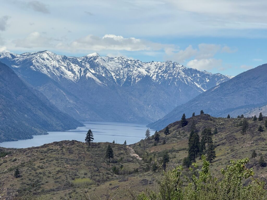
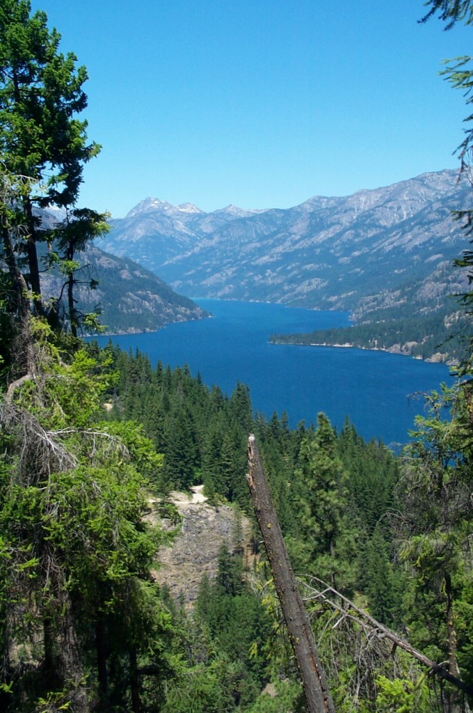
The result is a lake that resembles a fjord more than a typical inland waterway: narrow, extraordinarily deep, and flanked by slopes that rise sharply from the water’s edge.
The Lake as a Shared Resource
Lake Chelan functions as both a shared resource and a defining boundary for the communities that surround it.
The lake is fed primarily by the Stehekin River and Railroad Creek at its upper end. At its southern end, the lake drains toward the Columbia River. The Lake Chelan Dam, constructed in 1927, controls this outflow — regulating water levels for irrigation, hydropower, and downstream water management. The dam transformed the lake’s shoreline and remains a foundational piece of regional infrastructure.
For lower-valley communities — centered around the City of Chelan — the lake supports recreation, irrigation, and local economies.
For upper-valley communities like Stehekin, the lake remains the primary transportation corridor. Without road access, the ferry that runs the full length of the lake is not just a scenic attraction — it is the primary means of moving people, supplies, and freight in and out of the community year-round.
Water levels, shoreline conditions, and seasonal access shape how people live, work, and move through the region throughout the year.
How the Lake Shapes the Valley
Understanding Lake Chelan helps explain why the valley looks and operates the way it does.
Communities, roads, parks, marinas, and working lands are all arranged in response to the lake’s depth, length, and orientation. Rather than serving as a backdrop, Lake Chelan actively structures the rhythm of life in the valley — influencing everything from seasonal population changes to how residents relate to the surrounding landscape.
From South Shore to Stehekin
The lake spans two very different worlds.
The developed south shore, anchored by the City of Chelan, offers easy lake access, public beaches, marinas, and waterfront parks.
The upper reaches near Stehekin are remote and roadless — accessible only by boat or floatplane — and bordered by the North Cascades National Park Complex and the Lake Chelan National Recreation Area. A ferry ride from the town of Chelan to Stehekin takes approximately four hours and covers the full length of the lake.
This range — from a busy resort town to a roadless wilderness village — is what makes Lake Chelan unlike most lakes in Washington State.
Ancient Human Presence
Lake Chelan has been a place of human habitation for thousands of years. Human history around the lake stretches back more than 10,000 years, when Indigenous peoples — known today as the Chelan, an Interior Salish group related to the Wenatchi — settled along its shores. The name “Chelan” comes from a Salish word meaning “deep water.”
Evidence of that long presence remains visible on the landscape today. Pictographs — painted figures and symbols on cliff faces — can be found along the lakeshore, including near Domke Falls on the upper lake and in the Stehekin area at the head of the lake.
These painted rocks were noted by 19th-century travelers. In summer, the pictographs appear near the waterline. In winter, when the lake level drops, they appear higher on the cliff face — a shift that raises questions about the water conditions that existed when they were first made.
Written records from 1866 describe the pictographs and note that even the Indigenous people of that era recognized them as the work of earlier peoples. Their placement — on rock faces accessible only by water — reflects a deep and continuous human relationship with this place long before non-Native settlement began in the late 1800s.
Peaks of the Valley
Lake Chelan sits between two distinct mountain systems, one flanking each side of the valley corridor.
South and Southwest — The Chelan Mountains
The Chelan Mountains run roughly 40 miles along the southern shore of Lake Chelan, forming a rugged wall between the lake and the Entiat River valley. Most of the range sits within the Wenatchee National Forest, with the northern end reaching into the Glacier Peak Wilderness.
Notable peaks in this range include:
- Cardinal Peak — 8,590 ft — the highest point in the Chelan Mountains
- Pyramid Mountain — 8,243 ft — on the west side of the lake, with views across the full length of Lake Chelan from its summit
- Castle Rock — 8,166 ft — above the western shore, rising more than 7,000 feet above lake level within a horizontal distance of about 2.5 miles
- Emerald Peak, Saska Peak, and Pinnacle Mountain — each exceeding 8,000 feet in the northern portion of the range
North and Northwest — The North Cascades
The upper reaches of Lake Chelan are bordered by the terrain of the North Cascades — craggy peaks, spires, ridges, and deep glacial valleys shaped by the same forces that carved the lake itself.
The Stehekin Valley, at the head of the lake, opens into a corridor leading toward the high North Cascades and the surrounding wilderness areas of the Lake Chelan National Recreation Area.
Frequently Asked Questions
Where is Lake Chelan?
Lake Chelan is located in Chelan County, north-central Washington State. The town of Chelan sits at the southern end of the lake, near its outlet toward the Columbia River. The lake stretches northwest for more than 50 miles, ending at the remote community of Stehekin near the border of the North Cascades.
What is Lake Chelan?
Lake Chelan is a glacier-carved lake in Chelan County, north-central Washington State. It stretches more than 50 miles from its southern outlet near the Columbia River into the North Cascades. It is the deepest lake in Washington State and the third deepest in the United States.
How deep is Lake Chelan?
Lake Chelan reaches a maximum depth of 1,486 feet, making it the deepest lake in Washington State and the third deepest in the United States.
To put that in perspective, the lake bottom at its deepest point lies approximately 388 feet below sea level — the result of repeated glacial scouring that carved an extraordinarily deep trough through the mountains long before the lake existed.
How long is Lake Chelan?
Lake Chelan is approximately 50 miles long and one to two miles wide. Its narrow width relative to its length gives it the appearance of a fjord rather than a typical lake.
How was Lake Chelan formed?
Lake Chelan was carved by repeated cycles of glaciation over hundreds of thousands of years. Continental ice sheets moving south from Canada, combined with high-elevation alpine glaciers, ground deep into the bedrock, forming the long, narrow, U-shaped valley the lake now occupies.
What is the Lake Chelan Dam?
The Lake Chelan Dam was constructed in 1927 at the southern outlet of the lake. It controls the flow of water from Lake Chelan toward the Columbia River, supporting irrigation and hydropower for the region. The dam transformed the lake’s water level and remains a core piece of infrastructure in the valley.
Were Indigenous people present at Lake Chelan?
Yes. Human history around Lake Chelan stretches back more than 10,000 years. The Chelan people, an Interior Salish group, lived along its shores. Pictographs still visible near Domke Falls and in the Stehekin area are among the evidence of that long human presence.
What mountain ranges border Lake Chelan?
The Chelan Mountains run along the southern shore, with peaks reaching above 8,500 feet. The northern shores and upper reaches of the lake are bordered by the North Cascades, including the Glacier Peak Wilderness and the Lake Chelan National Recreation Area.
How do you get to Stehekin?
Stehekin has no road connection to the outside world. It is reached by passenger ferry, floatplane, private boat, or on foot by trail. The passenger ferry from the town of Chelan takes approximately four hours.